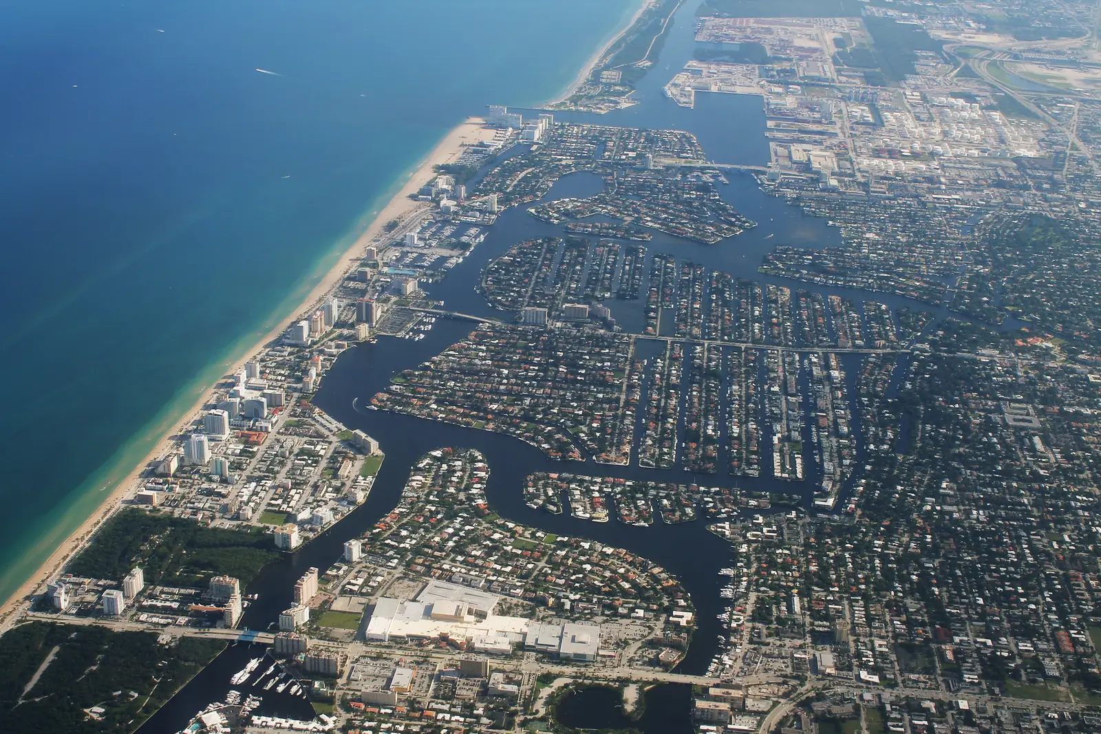
11 Fort Lauderdale neighborhoods from Imperial Point to Riverland: ZIP codes, zoned schools and their 2026 grades, and August 2026 Zillow values.
Last checked Oct. 8, 2026. Sources: the City of Fort Lauderdale’s neighborhood associations layer, its 2026 list of neighborhood associations and its parcel points; Broward County’s city limits, address points and 2025-26 school boundaries; the Florida Department of Education’s 2026 school grades; Zillow Research; the Census Bureau; and OpenStreetMap.
Fort Lauderdale is a city of 185,604 people, according to the Census Bureau’s 2020-2024 American Community Survey, in Broward County. It runs from the barrier island and the beach on the east, across the Intracoastal Waterway and a web of canals and rivers, to west of I-95. Federal Highway (U.S. 1) is the main north-south road through the middle, and I-95 runs north to south on the west side, with exits that include 27, Broward Boulevard, 29, Sunrise Boulevard, and 33, Cypress Creek Road. The New River winds through downtown. City Hall is at 100 N. Andrews Ave.
Three things to know before you look at a listing:
- Eleven ZIP codes. Of about 35,900 street addresses inside the city in Broward County’s address data, 25% are in 33312, 18% in 33311, 12% in 33308, 9% in 33315, 8% each in 33304 and 33301, 6% each in 33305 and 33316, and smaller shares in 33309, 33334 and 33306. Some of those ZIP codes also take in Oakland Park, Wilton Manors and other neighbors.
- Six high school zones. In Broward County’s 2025-26 school boundary data, 35% of addresses in the city are zoned for Fort Lauderdale High, 31% for Stranahan High, 14% for Northeast High in Oakland Park, 12% for Dillard 6-12, 6% for South Plantation High and 3% for Boyd H. Anderson High in Lauderdale Lakes. School zones do not follow city limits; always check one address with the district’s Find My School tool.
- Many small neighborhoods. The city’s neighborhood associations layer maps 86 association areas, from single condo buildings to whole districts, and the city keeps a yearly list of the ones it officially recognizes. Our guide covers 11 of them, spread across the city from the beach to I-95.
The areas at a glance
Typical home value is the Zillow Home Value Index for the area’s main ZIP code in August 2026: a modeled typical value for the middle third of homes, single-family homes and condos together, not a sale price. It is a ZIP code figure, so it is the same for every area in that ZIP code. School grades are the Florida Department of Education’s 2026 grades.
| Area | Main ZIP | Zoned high school (2026 grade) | Typical home value (ZIP) | Guide |
|---|---|---|---|---|
| Downtown | 33301 | Fort Lauderdale (A) north of the river, Stranahan (A) south | $863,144 | Downtown |
| Flagler Village | 33301 | Fort Lauderdale (A) | $863,144 | Flagler Village |
| Sailboat Bend | 33312 | Stranahan (A) | $483,310 | Sailboat Bend |
| Victoria Park | 33301 | Fort Lauderdale (A) | $863,144 | Victoria Park |
| Rio Vista | 33316 | Fort Lauderdale (A) | $728,715 | Rio Vista |
| Central Beach | 33304 | Fort Lauderdale (A) | $595,863 | Central Beach |
| Galt Mile | 33308 | Fort Lauderdale (A) | $520,591 | Galt Mile |
| Coral Ridge | 33304 | Fort Lauderdale (A) | $595,863 | Coral Ridge |
| Imperial Point | 33308 | Northeast (B) | $520,591 | Imperial Point |
| Lauderdale Manors | 33311 | Dillard 6-12 (C) | $365,913 | Lauderdale Manors |
| Riverland | 33312 | Stranahan (A) | $483,310 | Riverland |
Victoria Park and Coral Ridge are split across ZIP codes; their pages give each one. The citywide Zillow figure was $511,473 in August 2026, down 1.3% from a year earlier.
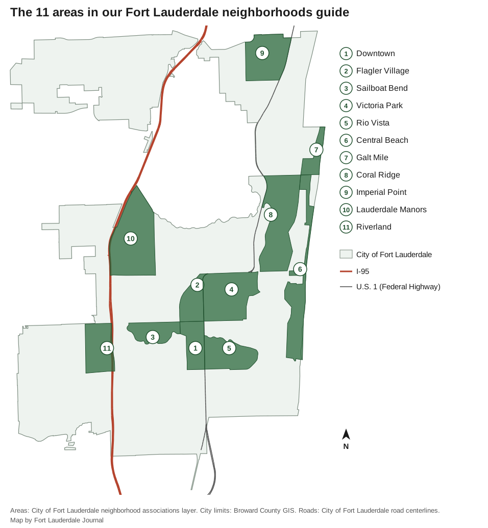
Map by Fort Lauderdale Journal. Areas: City of Fort Lauderdale neighborhood associations layer. City limits: Broward County GIS. Roads: City of Fort Lauderdale road centerlines.
Downtown and the river
Downtown is high-rise condos and offices on both banks of the New River between Broward Boulevard and Davie Boulevard, in ZIP 33301, with the Riverwalk, the Main Library and the Broward Central bus terminal. North of the river it is zoned for Fort Lauderdale High, south of it for Stranahan High.
Flagler Village, north of Broward Boulevard and west of Federal Highway, mixes condos, apartments and commercial property. It is about 0.4 mile by road from City Hall and zoned for Fort Lauderdale High.
Sailboat Bend, just west of downtown where the New River bends, is home to the Sailboat Bend Historic District, which takes in about two-thirds of its parcels. It is in ZIP 33312 and zoned for Stranahan High.
Rio Vista, south of the New River and east of Federal Highway, is mostly single-family homes, 885 of its 1,103 parcels, and is zoned for Harbordale Elementary, Sunrise Middle and Fort Lauderdale High, all A schools in 2026.
East of Federal Highway
Victoria Park runs from Federal Highway to the Middle River between Broward and Sunrise boulevards, with Holiday Park on its north side. About half of its 3,795 parcels are single-family homes.
Coral Ridge is the waterfront neighborhood between the Middle River and the Intracoastal from Sunrise Boulevard to Oakland Park Boulevard, split across ZIP codes 33304, 33305 and 33306 and zoned for Bayview Elementary, an A school.
Imperial Point, at the city’s north end west of Federal Highway, is the one area in our guide zoned for middle and high schools outside the city: Pompano Beach Middle and Northeast High in Oakland Park. It is about 1.8 miles by road from I-95 exit 33.
The beach
Central Beach is the barrier island strip between the Intracoastal and the Atlantic along A1A, almost all condos, with the public beach park and the Fort Lauderdale Aquatic Complex.
The Galt Mile, north of Oakland Park Boulevard on the beach, is all condominium and co-op towers in ZIP 33308, with no single-family homes in the city’s parcel data.
West of downtown
Lauderdale Manors, north of Sunrise Boulevard and east of I-95, is single-family homes in ZIP 33311, with Lauderdale Manors Park and Mills Pond Park. It is zoned for Dillard 6-12, a C school in 2026.
Riverland, between Broward and Davie boulevards at I-95, is single-family homes in ZIP 33312 with its own elementary school and the Fort Lauderdale Tri-Rail station. It is the closest area in our guide to the airport, about 5.6 miles by road.
Comparing the city with its neighbors
For property tax rates, high school grades, home values, income and commute times side by side with Wilton Manors, Oakland Park and Lauderdale Lakes, see Fort Lauderdale vs Wilton Manors vs Oakland Park vs Lauderdale Lakes. More background in moving to Fort Lauderdale, home prices, schools, property taxes, parks and trails and getting around.
How we built this
- Which areas. We started from the City of Fort Lauderdale’s neighborhood associations layer, which the city describes as areas where associations are “formed by residents and property owners in a contiguous area generally to advocate for or organize activities,” some of them “sanctioned and recognized by the City.” We chose 11 areas spread across the city, 10 of them on the city’s 2026 recognized list; Riverland is on the city’s list of associations not recognized this year. OpenStreetMap place names inside the areas were checked against the city’s map.
- What each area holds. Housing counts and ZIP codes come from the city’s parcel data, which records the association each parcel belongs to.
- Schools. Every parcel was matched to Broward County’s 2025-26 school boundary layers, and every school to its 2026 grade from the Florida Department of Education.
- Distances are measured on the OpenStreetMap road network with the OSRM routing engine and are distances, not drive times. Park, library and store locations come from the city’s facility data and © OpenStreetMap contributors.
- What we leave out. We do not rank areas or describe who lives in them, and we name no subdivisions except where the city or OpenStreetMap names them as places.
Frequently asked questions
What are the neighborhoods in Fort Lauderdale, Florida?
The City of Fort Lauderdale’s neighborhood associations layer maps 86 association areas. Our guide covers 11: Downtown, Flagler Village, Sailboat Bend, Victoria Park, Rio Vista, Central Beach, the Galt Mile, Coral Ridge, Imperial Point, Lauderdale Manors and Riverland.
What ZIP codes are in Fort Lauderdale?
Eleven ZIP codes cover most of the city. Of about 35,900 street addresses inside the city in Broward County’s address data, the most are in 33312 (25%), 33311 (18%), 33308 (12%) and 33315 (9%).
What high school is Fort Lauderdale zoned for?
It depends on the address. In Broward County’s 2025-26 school boundary data, 35% of addresses in the city are zoned for Fort Lauderdale High, 31% for Stranahan High, 14% for Northeast High, 12% for Dillard 6-12, 6% for South Plantation High and 3% for Boyd H. Anderson High.
Do Fort Lauderdale school zones follow city limits?
No. All public schools are run by Broward County Public Schools, and parts of the city are zoned for Northeast High in Oakland Park, Boyd H. Anderson High in Lauderdale Lakes and South Plantation High. Check an address with the district’s Find My School tool.
Which Fort Lauderdale ZIP code has the highest Zillow value?
Of the city’s ZIP codes, 33301, around downtown, Rio Vista and Victoria Park, had the highest typical value in August 2026: $863,144, according to the Zillow Home Value Index. The lowest was 33311, at $365,913.
Have your say