Mayor Dean J. Trantalis declared a local state of emergency Wednesday after up to 7.42 inches of rain fell in the city. The flood watch runs until 7 p.m. Thursday.
Overview
Updated Nov. 18: Mayor Dean J. Trantalis declared a local state of emergency at 11:31 a.m. Wednesday after overnight rain flooded parts of the city. The page now has the rain totals, the city’s response, the free parking garage and Wednesday’s school closures.
Fort Lauderdale is under a local state of emergency for flooding. Mayor Dean J. Trantalis signed the proclamation at 11:31 a.m. Wednesday. It runs for seven days unless he changes or ends it.
The proclamation says the city has had “excessive rain resulting in localized flooding” since Nov. 17. It lets the mayor make emergency rules, buy supplies and call on city staff. Any rules he makes must be confirmed by the City Commission as soon as it can meet.
A flood watch from the National Weather Service in Miami still covers all of Broward County until 7 p.m. Thursday. The city said in its flooding update that another 2 to 4 inches of rain was expected Wednesday.
How much rain fell
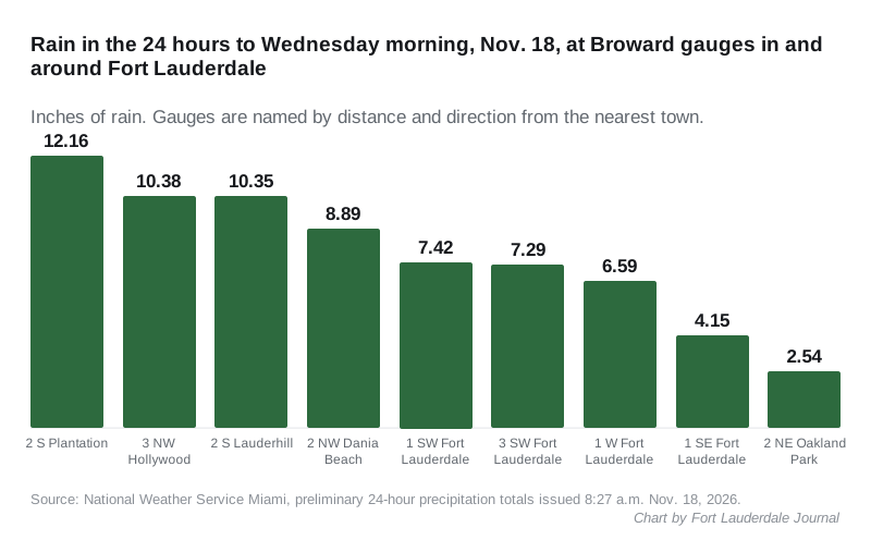
Rain gauges in Fort Lauderdale recorded up to 7.42 inches in the 24 hours to Wednesday morning. The figures are from the weather service’s preliminary rain totals, issued at 8:27 a.m. Wednesday. Gauges are named by distance and direction from the nearest town.
- 1 SW Fort Lauderdale: 7.42 inches
- 3 SW Fort Lauderdale: 7.29 inches
- 1 W Fort Lauderdale: 6.59 inches
- 1 SE Fort Lauderdale: 4.15 inches
The heaviest rain fell west and southwest of the city. The top total in Broward County was 12.16 inches at a gauge 2 miles south of Plantation, about seven miles southwest of downtown Fort Lauderdale. Gauges 2 miles south of Lauderhill, about four miles west, and 3 miles northwest of Hollywood each had more than 10 inches.
Other Broward totals in the same report:
- 2 NW Dania Beach: 8.89 inches
- 2 NE Oakland Park: 2.54 inches
The weather service’s forecast discussion on Wednesday said “impactful flash flooding is ongoing across portions of SE Florida.” It said the risk is expected to continue over the coming days.
What the city is doing
The city said crews worked through the night and will keep working around the clock for the next several days. Its 10 a.m. update listed these steps:
- the city’s full fleet of vacuum trucks sent to flooded areas, with emergency contractors brought in
- portable pumps in use in flooded areas
- utilities crews watching the wastewater system, which the city said is under “significant strain”
- Fort Lauderdale Fire Rescue’s high-water rescue vehicles deployed and ready
- the city’s emergency management team working with Broward County Emergency Management
The city said more rain could slow how quickly floodwater goes down. Ground that is already saturated raises the risk of flash flooding in low-lying neighborhoods, it said.
Free parking on higher ground
The city opened the Riverwalk Center Garage, 150 SE Second St., free to residents who want to move their cars out of flood-prone streets. Park on the second floor or higher. The free parking runs until 9 a.m. Friday, Nov. 20, the city said.
Schools
Broward County Public Schools closed Wednesday, Nov. 18, and canceled after-school programs, the city said.
The flood watch
The weather service renewed the flood watch at 12:50 p.m. Wednesday. It covers coastal, metro and inland Broward County, along with Palm Beach and Miami-Dade counties, through Thursday evening.
The watch says:
- several rounds of storms may bring 2 to 4 inches of rain through late Thursday
- 6 to 8 inches, and isolated spots over 10 inches, may be possible
- some storms may drop 1 to 2 inches an hour
- flooding may hit poor drainage and urban areas, and low-lying and flood-prone places
A watch means flooding is possible. The weather service said to be ready to act if it issues a flash flood warning.
What comes next
The weather service’s forecast discussion said high pressure north of Florida and a weak low in the Gulf are holding a stalled front over the state. That keeps deep moisture over South Florida. Forecasters said storms that line up along the coast could repeat over the same urban areas and cause flash flooding.
They said the east coast will be favored for heavy rain Wednesday and Thursday. Their figures for the next 48 hours:
- 2 to 4 inches across most of Southeast Florida
- a reasonable worst case of another 5 to 8 inches where storms repeat
Forecasters said Friday could bring one more day of heavy rain, especially early, but gave that part of the forecast low confidence. They expect drier air over the weekend, with a 10% to 20% chance of scattered showers each day into early next week.
The Fort Lauderdale forecast updated Wednesday afternoon breaks it down:
| Period | Chance of rain | New rain possible |
|---|---|---|
| Wednesday afternoon | 80% | a quarter to half an inch |
| Wednesday night | 80% | 1 to 2 inches |
| Thursday | 90% | three-quarters of an inch to 1 inch |
| Thursday night | 50% | not given |
| Friday | 40% | not given |
East winds gusting to about 30 mph are forecast Wednesday afternoon.
Surf and rip currents
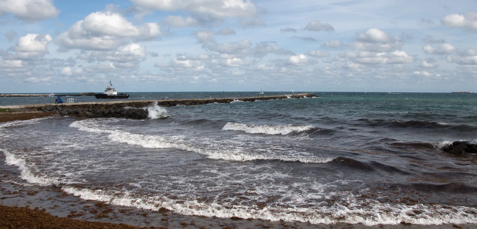
The high surf advisory for coastal Broward County runs until 7 p.m. Thursday, with breaking waves of 5 to 9 feet. The high rip current risk now runs through Friday evening.
The weather service listed these impacts:
- dangerous swimming and surfing conditions
- localized beach erosion
- rip currents that “can sweep even the best swimmers away from shore into deeper water”
It said inexperienced swimmers should stay out of the water. The forecast discussion called the rip currents and surf “life threatening” for Miami-Dade, Broward and Palm Beach beaches through the rest of the week. Offshore, Atlantic seas are expected to climb to 8 to 12 feet through Thursday.
What it means for you
- Stay off the roads in heavy rain. The city asked people to avoid unnecessary travel during downpours and never to drive through flooded streets.
- Drive slowly through standing water. The city said wakes from cars push floodwater into homes and businesses.
- Move your car if your street floods. The Riverwalk Center Garage is free on the second floor and above until 9 a.m. Friday.
- Keep out of floodwater. The city said it may carry contaminants or hide hazards. Clear storm drains near you only when it is safe.
- Report a flooded or impassable road to the city’s Customer Service Center at 954-828-8000 or through FixIt FTL. For a life-threatening emergency, call 911.
- At the beach: swim near a lifeguard. If a rip current catches you, relax and float, and do not swim against it. Swim parallel to the shoreline if you can.
- Watch for warnings: a flash flood warning means flooding is happening or about to. Alerts for the city are on the National Weather Service alerts page for coastal Broward.
Have your say